TOUR DE FRANCE GOES GOOGLE

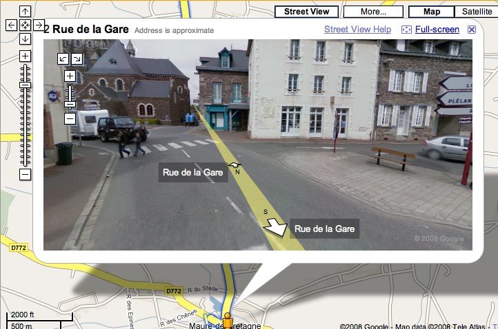
Internet supremo Google has today announced the release of a new feature on its Google Maps which allows you to view street-level imagery of the route of the 2008 Tour de France, which starts tomorrow.
Each of the 21 stages are be clearly marked on the map, taking you on a journey of more than 3,500 km (2,200 miles), from the coast of Brittany, around the 21 hairpin bends of the notoriously steep Alpe d'Huez to the finishing line on the cobbled streets of the Champs Elysees.
Street View is a feature of Google Maps that enables users to view and navigate within 360 degree street-level imagery - think of it as a riders' eye view of the route. The detail is fascinating, you can zoom in and out of images and rotate them, as if turning your head, to see each side of the street. It appears as though one image has been taken every 5-10 metres.
The map is available at www.google.co.uk/tourdefrance2008.
Christian Prudhomme, director of the Tour de France said "This is a new way for Tour de France fans to immerse themselves in the race, discovering the podiums where the winners will stand, or finding a city or route where the peloton will pass."
"I am sure the Tour's audience will make use of this surprising feature. I am very proud that, like the Tour de France, Google Maps is helping to give visibility to the regions of France."
Learn how to use Street View here: http://maps.google.fr/help/maps/streetview/
Get The Leadout Newsletter
The latest race content, interviews, features, reviews and expert buying guides, direct to your inbox!
| TOUR DE FRANCE 2008: GUIDE |
Tour de France 2008 homepage>>
News and features>>
Route & stages>>
Teams and riders>>
About the Tour>>

Thank you for reading 20 articles this month* Join now for unlimited access
Enjoy your first month for just £1 / $1 / €1
*Read 5 free articles per month without a subscription

Join now for unlimited access
Try first month for just £1 / $1 / €1
Founded in 1891, Cycling Weekly and its team of expert journalists brings cyclists in-depth reviews, extensive coverage of both professional and domestic racing, as well as fitness advice and 'brew a cuppa and put your feet up' features. Cycling Weekly serves its audience across a range of platforms, from good old-fashioned print to online journalism, and video.
-
 Gear up for your best summer of riding – Balfe's Bikes has up to 54% off Bontrager shoes, helmets, lights and much more
Supported It's not just Bontrager, Balfe's has a huge selection of discounted kit from the best cycling brands including Trek, Specialized, Giant and Castelli all with big reductions
By Paul Brett
-
 7-Eleven returns to the peloton for one day only at Liège-Bastogne-Liège
Uno-X Mobility to rebrand as 7-Eleven for Sunday's Monument to pay tribute to iconic American team from the 1980s
By Tom Thewlis